Washington
State
After
leaving Utah I timed it so I would race thru the SW tip of Idaho and reach Dead
Man’s Pass in Oregon during the cool time of the morning. Then I chilled on top the Pass till the
evening and took off for the Gorge. I had meant to go up thru Idaho but went conservative since I didn't trust the Motorhome engine to cooperate.
There
is a spot near The Dalles where you can get a shot of Mt. Hood with one of the
Dams in the Foreground….but you get the power pole too. This is not texting while driving don't worry. It's only photographing while driving !
And
because I’m driving I can’t get great pictures but the take home message is
“The Scenery has CHANGED”.
Arriving
in SW Washington I decided to spend a little time and get some exercise so I
hiked the Beach at Grayland (no Pics) and then took a trip to St. Helens to
hike there.
I
had never really done any hiking there so this is a light hike that gives a better
view into the crater I thought would be cool.
Notice
toward the center of the picture the dark ‘lips’ around the lighter inside?
Inside
you can see steam clouds and snow melt cascading down. All the Washington Volcanoes still throw off
steam just to let you know they aren’t ‘Done’ yet.
All
of my pictures of St. Helens from blast date are on film and I think Gina has
the albums or maybe they are on slides and are in California. I can tell you things are a lot greener, even
though it has a long way to go. I wasn’t
expecting wildflowers!
It’s
a rare day to find St. Helens cloudless so I was pretty lucky. It was also warm but a cool ‘air-conditioned’
breeze.
None
of that green was there for quite a long time, if you call 37 years a long time.
Mt.
Adams is just over the hill and thru the woods a little ways.
That
is now Spirit Lake
Don’t
know if you see all the ‘sticks’ laying down, but those trees' limbs were
incinerated and the trunks blown flat away from the blast.
Some
trunks splintered from their stumps and some were uprooted. Many splintered stumps remain. On Forest Service land it was decided not to
interfere with Mother Nature’s process so everything was left lay. Weyerhaeuser attempted to salvage on their
land but the ash made lumbering next to impossible. They did, however plant noble fir and were
quite successful in establishing stands.
Nothing in the surrounding landscape exceeds 37 years age though.
It
is still a site of awe and destruction
with life trying to gain a foothold.
My
shoes were gray with ash after hiking the Five mile round trip trail to the overlook I chose.
But
now let’s switch gears… or mountains. This is two days later because I need a day off after most hikes.
This is the Ohanapecosh River.
No,
I can’t say it either but it runs south east of Mount Rainier near the Grove of
Patriarchs. With the bottom made up of
large rounded rock, only the sides brim with powdery sand similar to what I
hiked at St. Helens.
This
is a protected stand of some of the few remaining old growth forest
environments left in Washington. If it
appears dark it is because…it is!
There
is quite a canopy above.
There
are other stands like this in the Cascades and Olympic Peninsula mountains. Hopefully most are protected in some form. I just stopped here on the way to Mt. Rainier
for a leg stretch. The pics I took
didn’t turn out that great with light and shade and the fact that
The
trees are too big to get pictures of!
Like the Redwoods, they are in a community but in this spot
Trying
to get depictive pictures seemed futile, but seeing with the eye was simple.
So
up to Paradise I went for my hike. This
is the Guide Shack at Paradise. Quite
the slope on the roof. I think they are
concerned about snow load!
This
is the visitor’s Center. The NEW
Visitor’s Center for me. Built in 2008
with a more efficient design for heat and snow load, it replaced the one I
remembered that was round with a 360 degree view. The ‘kid’ who said this was a more efficient
design may have been fooled because this is one big open room from floor to
roof. Well, I guess all the heat will go
melt the snow on the roof, so wear your coat when you go in. It is July though so no worries. I didn’t get
a picture of the Lodge ‘cause well, it wasn’t in my walking path to what I
wanted to see which was namely flowers and mountains.
I
came for this
This
This
And
this
But
those came late in the day since most of the day the mountain was playing
peekaboo with the clouds
But
tho the mountain itself was quite elusive, the mountain side gave a very
satisfying day. Alpine Fir is one of my
all time favorite trees anyway and the wildflower display...
Was awesome. The
variety of plants in bloom and the beautiful weather made the trip a real joy.
Because
there was such a heavy snow fall the past winter, and because July still has
plenty of snow to melt…
The
watersheds were still very active and moisture was everywhere.
The
Marmots didn’t mind and were posing everywhere for anyone who would ‘shoot’ them…and
we all did!
Rainier’s
Meadows are mature and healthy. They are
spectacular and one of the best places in the world to see wildflowers in an
Alpine setting.
If
the marmots are to blame for this landscape design they did one outstanding job
and Mother Nature should give them an “ATTA RODENT” for a job well done.
We’ll
get into this deeper because the meadows are enormous, the flowers brilliant
and lush, the scenery everywhere….and it is sooooo GREEN!
But
I want to tell you a little about Skyline Ridge Trail. This is a five mile loop that goes really,
really, really high! Higher than what I
had remembered.
When
it starts, it is very well marked. And
it is very well laid out
And
the scenery along the way, vista’s
Vista’s
looking Down
Vista’s
looking out, believe it or not, you are
looking at Mt. Adams, Mt. Hood…100 miles away, and Mt. St. Helens….Adams and
Helens both about 40 miles. I’ll show
you.
Adams
left, Hood middle, Helens right…ok, just a minute
Adams….the
best I can do
Hood
middle…..100 miles away!!!
And
St. Helens
Here
is one more, a panoramic so you may have to scroll to see it all, because if you ever come see this you will see it all
and all at once without a camera lens, and your jaw drops.
Ok,
then still, there are Vista’s looking up
Which
by the way, if you can see the ‘trail’ we are still going up. Trouble is, it starts to get a little
confusing as you trek across the snow and the footprints start to disperse into
‘ go where ever you want’ ‘just don’t go the wrong way’ syndrome.
Ok,
so I skipped this and some very nice scenery along the way. We will come back but I want to scare
you….think I can’t? Well, I scared
MYSELF so just run with me. Just wanted you to know there are waterfalls and wildflowers everywhere!
This
will be the last clue for the trail. The snow gets
deeper and the signs don’t. Guess they
thought I would know!! Ha Ha Ha, what in gods name were they thinking??!!
Periodically
I would see a human…..not on this trail but way up or way down and they would
shout “am I going the right way” and I swear I would say ‘Your fine’ but ‘
where are you going?’ I couldn’t tell if
they were going with me or against me!!
There are switch backs you know….or…are there?? There are other trails also. Like those that go to the summit! Yah, no, I'm not wanting that!
This
looks safe, others have done it, right?
The snow above better not start going below while I’m here!!
Yah,
I feel real good about this, those dam marmots!! (I don’t like to cuss on line so I spell
funny instead)
I
just realized. During the time that I
thought I was surely going to die I took no pictures because I am sure I went
to survival mode and just started humpin’.
Anyway, you missed some very intense moments of mountaineering by a guy
who is better walking the streets of Pigs knuckle Junction.
So
let’s just start from the top….which I was never close to!! That’s over 14,000 ft, colder than a well
diggers….oh, sorry, I forgot, no cussing.
That
my friends is the beginning of the Nisqually Glacier, which used to be enormous
and now is barely in existence.
That
is the high end of it. I AM ABOUT 6,000
SO THE TOP ISN’T MUCH MORE THAT ANOTHER MILE AND A HALF!
What’s a mile OR SO among hikers?! That last mile doesn't appear to have much for switch backs either, by the way.
Another
look
It
melts rather well and always has but also seems to be replenished in previous
years. As we all know, all glaciers are
receding. Normal event?
Who
cares, let’s just sit around and drill baby drill and let our kids, kids cross
that moat….oh, sorry…soap box!!!
This
would make a beautiful Black and White photo
The
low end in 1980 when I was here was way down that a way and this time I really
wasn’t able to get to the Glacier overlook so I’m not sure how much has vanished. What I see showing doesn’t look very
impressive as it did though.
That
now is in fact the head water of the Nisqually River that flows all the way to
Puget Sound emptying into the Nisqually Delta where in 2000 an under the Delta
earthquake occurred while our family was in Indiana for Mom’s funeral and the
earthquake took out our chimney in Olympia.
Wow, did that get off topic?
Fine,
we’ll talk about trees then
There’s
a couple
I
think it’s time to start breaking down some of this into smaller parcels
Namely,
it’s time to look a little closer
Instead
of these phenomenal landscape shots, let’s take a look at what the make up is.
Columbine
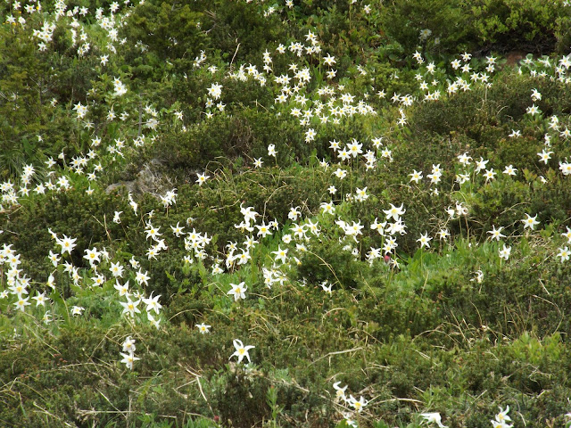
Glacier
Lily
Heather
Did
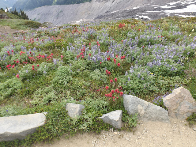
I say Lupine and Paintbrush?
Well,
did I?
How
about just Magenta Paintbrush
Or
my favorite Penstemon
Or Phlox…in
two colors
Ok,
yah, so I looked some of them up…. I bought the book this time!
July
is the time of year to get serious about Washington Cascade wildflower
hiking. Hopefully August will still be
good for areas farther north toward Mt. Baker and I’ll get one more opportunity.
Till
then, I dearly hope you enjoyed my babble along with the Evergreen States
finest display of nature. I'm almost at the North end of this year travels. Hope I don't get too busy to get more pictures. It’s Great to
be able to get outside!!


