Bryce
Canyon National Park
I
was a lot more impressed with Bryce Canyon than I expected to be. After the Grand Canyon and Zion, those are
hard acts to follow. I saw some very
impressive sites and learned some very impressive facts at Bryce.
Bryce
Canyon is in between, and connected to,
the Grand Staircase Escalante area and the Great Basin area. These are both immense areas of the west
combining more States than just Utah.
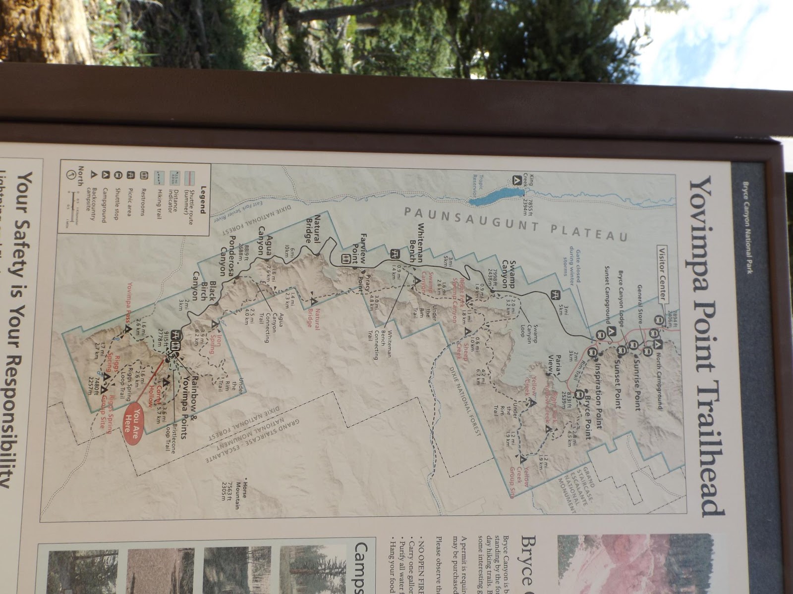
Yes this is sideways and North is to your right. Sorry, didn't want to break it up and this seemed like a way to show it all. The
road that you take to view Bryce Canyon is on the Paunsaugunt Plateau which
divides the area ( at the top, West, on the map). Everything to the west of the Plateau
drains into the Great Basin via the Sevier River that runs North. Everything to the east includes Bryce Canyon
and that part of the Grand Staircase (bottom of map).
confussed?

Ok, maybe this is better. This is about drainage.
So
all the soft sand sediment that comes off of Bryce Canyons Cliffs, Hoo Doos and
run off goes right into the Paria River. This is the Paria's headwater.
No wonder it looks like a chocolate milkshake! The Paria eventually runs to the Colorado and
monumental amounts of sediment from Bryce goes that way.
Now,
Why the name The Grand Staircase Escalante?
All the millions of years of sediment layers that make up the Western
USA in this area, and were then uplifted in different spots, are visible from
the very top layer…

Visible
at Powell Point, east of Bryce in the “Staircase” then subsequent layers can be
‘connected’ farther down the layered staircase in Bryce and finally the Grand
Canyon which has the oldest, deepest layers.
The bottom steps of the 'Staircase' so to speak.
Just
something I was not aware of, not being a Geologist! This is why they created the National Monument. This isn't visible from bottom step to top anywhere else.

Keep Powel Point in mind. I drove down Utah 12 to get a closer look as above but later you will see it in the far horizon from Bryce.

I
had some time before I could check into the next Hub, a KOA in Cannonvile, so I
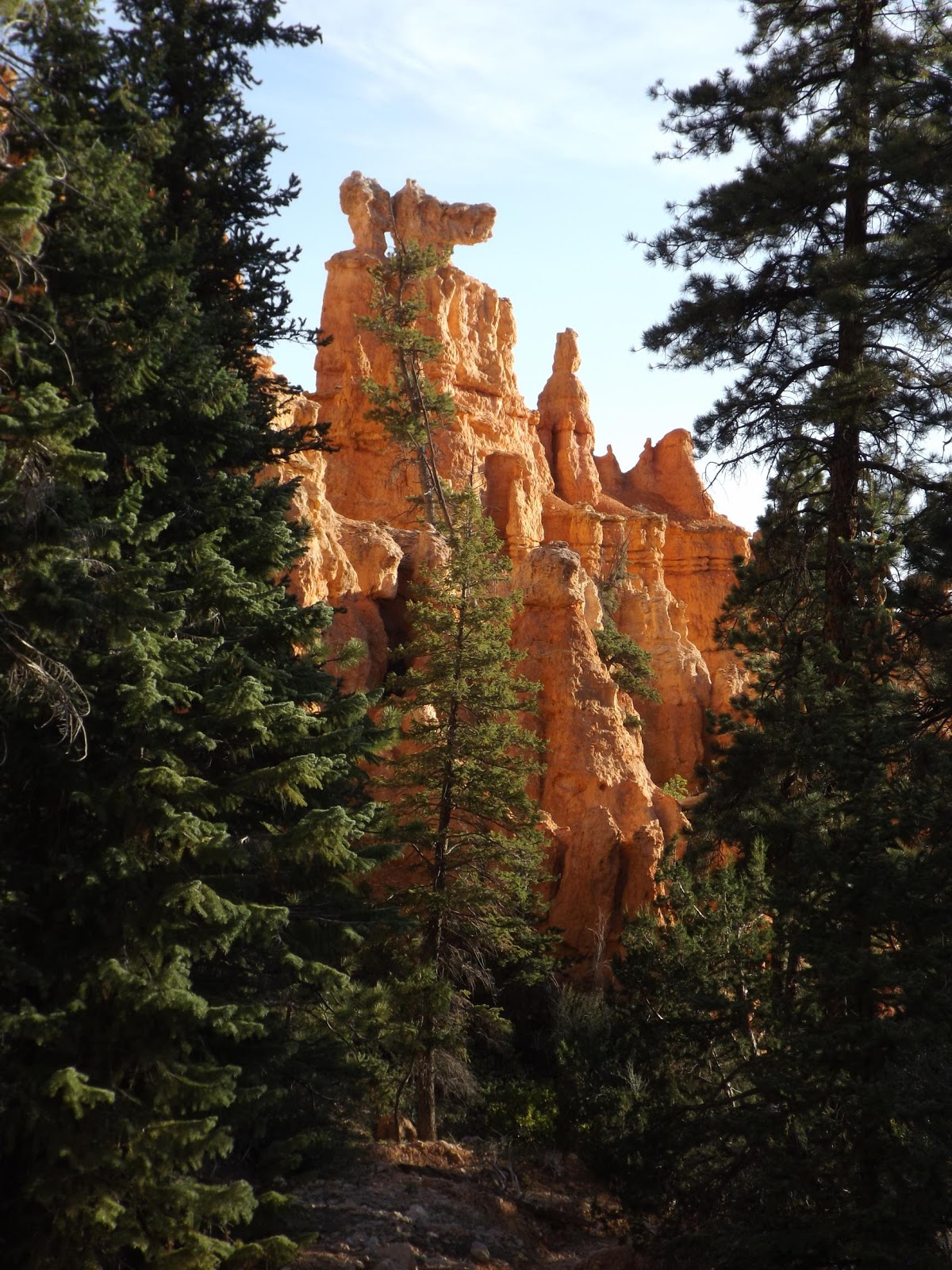
stopped before I got to Bryce Canyon for a 2 mile hike around Red Canyon, also a Federal set aside.

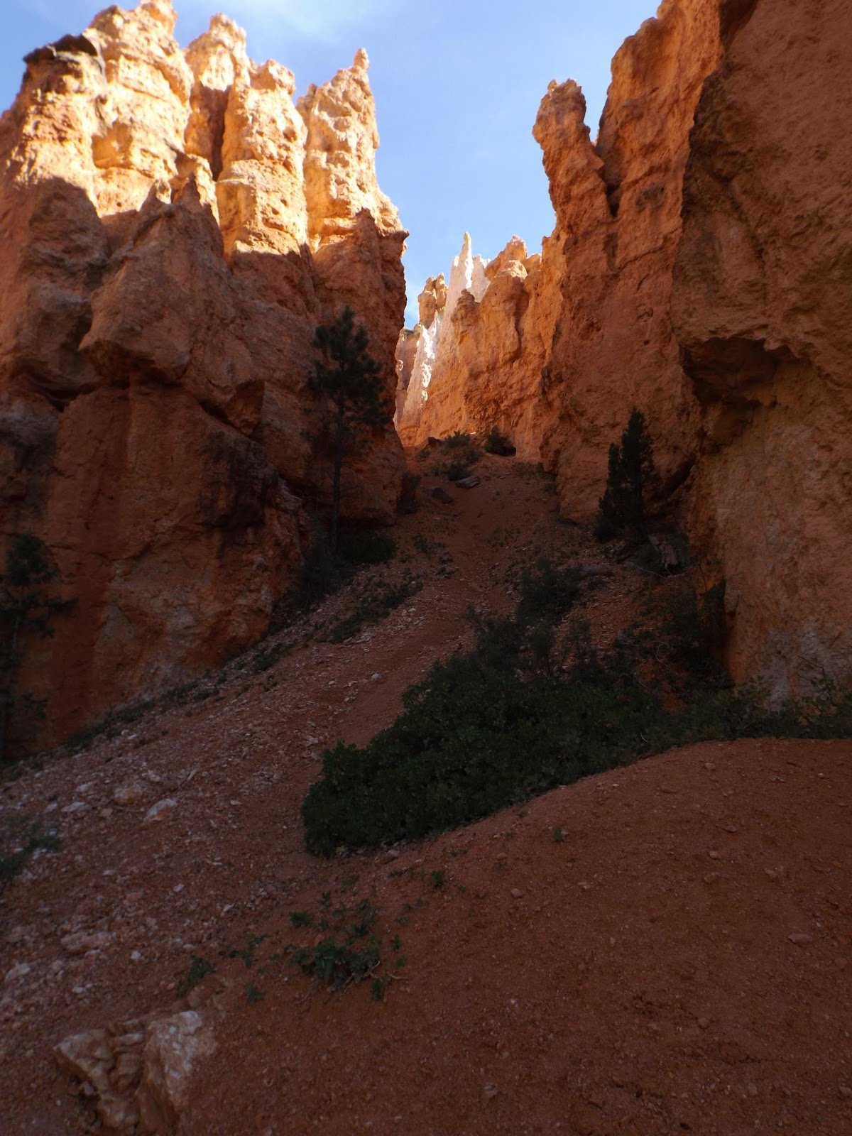
These
are Hoo Doo’s and are what remains of otherwise washed away 'Fins' of sediment
walls. I have a Hoo Doo Hike planned but needed a days rest…so ,
tomorrow I do the Hoo Doo!

Some of you remember Hooka's and the smoke from them. Ya, well, this is a cloud but it looks like the Hoo Doo Might have had a toke or two! A Hoo Doo is sediment that didn't wash away.
That
means that the top of that used to be under water and was sediment
deposited! Not that water was that high,
but that the area was uplifted that much!
Either way, a violent time for the earth.

Funny
thing, while I was Hoo Doo gazing my phone rang….and I had it with me!! Both very uncommon events! It was Gina so I sat in this ‘window’ and
talked to her for quite a while. Amazing
to have had reception because I lost it later not to be regained for days!

So
here is a question with no logical answer.
Are those Hoo Doo’s trying to be trees or is that Fir trying to be a Hoo
Doo?.....’if a woodchuck could chuck wood’!

There
I go again with the Birds and the Bees and the Rocks and the Trees, but they
just fit so nicely. And who said
anything about the moon!

The
colors just fit so well

Then
get a load of this little artsy fartsy touch of natures brush

Pretty
and Pretty impressive, but just wait for Bryce.

This
is what Bryce would have looked like, still partially covered with sandy silt while in it’s early erosion stage.

This
is Bryce currently and very magnificent it is!.. but someday, our children’s
children’s ….. will see this all eroded away to small mounds or maybe
flat. Nature is not done with its work,
but exposes such art all along the way.
Whoa, maybe it will get deeper!?

This, as was the above picture, is called the Bryce Amphitheater. The difference between the two is that for this one I got up at 4 a.m., drove into the park for sunrise and wow,wow,wow I'm glad I did!
The
‘Amphitheater’ at Bryce is one of the most amazing sites you will ever
see. And sunrise just makes it happen!!
What is tongue in cheek amazing is
that we don’t go there to see it. Everyone
there was talking French, German, Asian,
languages I couldn’t begin to identify.
I couldn’t make my sarcastic little (normal me) remarks to anyone
because I didn’t think they would ‘get it’….oh I know they wouldn’t get it…my
friends don’t always get it…my KIDs don’t always get it!!
What does one tourist say to another tourist if it isn’t some cunning or sarcastic little remark, anyway? I did try, failed and finally gave up being friendly! I stuck to just "WoW" and everyone got it!
What does one tourist say to another tourist if it isn’t some cunning or sarcastic little remark, anyway? I did try, failed and finally gave up being friendly! I stuck to just "WoW" and everyone got it!

“Those
are bigger where I come from”…
or

“Ours
are fresher, Those look so washed away”…

Wait,
stop! I was just getting started! You know us humans, just trying to be
cute! Don’t rain on my Parade!

Sorry, I jumped back a day for that cloud. That
cloud actually softened the glare that day. Light makes all the difference. Mid
day down pours are common this time of year so planning a hike or horse ride can be tough..

Lightning,
muddy trails, pool closures, but on the
‘bright side’ pictures come out better mid day with clouds.

The
sun definitely gives you challenges although the sunrise shots, while the sun is warm but not bright light, make it hard NOT to get a good picture. The
Park is open gated 24/7 so I knew I could get in.
Could I get up? I was lucky it was a spectacular morning and day.

Oh,
I have to mention, This is Bryce Creek, but it carries all its’ milky sediment
into the Paria River. Brice Creek drains Brice Amphitheater and all that sediment from those Hoo Doos' that will some day vanish.

Oh,
Remember I mentioned Powell Point at the
beginning? Here is a view from Bryce on
the skyline....way out there...

and blown up. It is the
“Top” of the Staircase, The Grand Canyon
bottom being the bottom of the Staircase.
I just thought that interesting.

I'm getting ready to do one of those hikes though where you start at the top and go down into those Hoo Doos', and at the
end have to come up…I call that bass ackwards but one of the girls at the
ranger counter gave me a tip to start at one spot that is a higher elevation and
end at a spot, though still going down then up, with less elevation and let the
shuttle take me back to the car. Really
smart idea because they too have a shuttle that goes the entire strip of the
Plateau with multiple buses so you don’t have to drive at all and can go
anywhere.

The
sky is truly the limit here because you don’t want to be down there when…

When
things get a little dicey up there ‘cause it gets slick, mushy and flash
floody.
I'm heading down and you will see, NOT SMALL!

That is where I will be and I'll take a shot of this view point from there...telephoto...

Not Telephoto!

Not Telephoto!


Sorry if there seems some redundancy here. I was experimenting giving the sun more time and messing with exposures....this is all within the Amphitheater and you just can't comprehend it with a photo.

Ok, you start from Bryce Point down these gentle switchbacks...gentle going down!

Now remember, I started at the top left ridge.

The path takes you thru a Window, although this one might have been man made.

Now we are below Hoo Doos' and you start to get an idea of

dimension.

a natural window for sure

We're still above many

and below as many! That is called the 'Wall of Windows'
this one could be a Snoopy look-a-like

Many take on forms, sometimes it's just their size as seen compared with this full sized tree as a sapling

Sometimes I see a Castle

Sometimes the Castle looks a little intimidating. Look how much better the right side shade lighting is, but with Panoramics I can't adjust. Your eye is able to pull all this in with perfect color. I wonder how the eye does that and why can't we figure that out?! oh, $$$$$$$ I'm not playing with a complete deck, huh?

OK, see them? Top center is the view point with humans.

In case you missed them


See the two colors on the wall by the path?

You might recognize something you saw from above at a different angle. The path takes you through the base of this colorful striated slope.

Perspective is entirely different from below. I wonder what a helo pick up might cost if I can't make the climb.

I can't get anymore dramatic than this 'Huggin' a Hoo Doo' shot

It's not only a beautiful hike thru the Hoo Doo, but it is a beautiful hike thru the trees.

Even when descending further like this switchback. It might be hard to visualize but when you see switchbacks, you know steep. Any steeper and I would need a ladder. Oh, wait, I forgot about steps!
Just wait for it!...

Oh but first another tunnel. I like to show the sides but it over exposes the opening, so...

Here is that

There are a lot of choices for pictures and this is only a fraction of what I took. Sorry if it is too many. Go get a drink and prop up your feet. We're down to the last 180 pictures!
So how many of those do you want to see? Ok, just a few more, I have to get out of this remember. You can feel my heart thumping.

Here are some more interesting ones. These look like match heads just waiting to be struck.

I don't know what this looks like, it just looks like neat Architecture!

There are those match sticks again but the background horizon is just gorgeous

Some of this may get re-captured but still warrant showing for the marvel effect.

I know! Down more!

This comes out awesome if I tilt my monitor....can you do that? Oh, well, sorry.

I must be getting close to the bottom of the hike, I can't go much lower or they'll have to open Hell's Gate!

Oh crap! I don't know about the bottom but look at the center, top, between those two tree trunks with the Fir in the middle. you see what I see?

Of coarse not cause the camera makes a pukie eye, but if I close in a little you see where I'm bound...way over/up there

Ok, I think this is going to be the final leg so get ready to sweat

This was the recommendation but it will also be an up hill killer

Supposed to be Wall Street


This is dry now but I wouldn't think it would take much to flow

Half That Whole Plateau has to come this way

I did mention stairs, Right? This leads into a slot however a very LARGE slot

And it is very Steep

Maybe the people help give you an idea of steep, All of a sudden this became Grand Central Station. Maybe a lot of these people turn back and never make the rest of the trip

Looking back down where I just came up. I am tired so why not stop and pretend I'm getting pictures so you can see the slope. Nope, It's all about I can't breath right now so this is an excuse!

So this is still yet to go....forever!

Another breath please

Oh good, a level spot. I don't wnat to see what is on the other side.

Stop again and look down before entering that tunnel

Ok, I think that is it

I think I should have started here going down. The going up was, well, a bit of a bitch frankly!! But now I feel all healthy and ready to ride the bus to get a Burger at the Lodge!
Protein!!!

My advice to those who will come here, see the Amphitheater last. That is Bryce point, Sunset and Sunrise points, Inspiration Point....the reason I say that is the rest is phenomenal in itself but to see those spots after the Amphitheater kind of takes the punch out of them. I saw the Amphitheater last and was glad I did because it is a show stopper! Hope you have enjoyed the show.
I'm heading out and now will be traveling more that seeing. I've decided to baby the Motorhome and travel in the wee hours 'cause I don't trust the engine in the heat and I want no more hassles. Maybe more pics when I get to Washington.
No comments:
Post a Comment